

Trail Highlights
UPDATES TO THIS PAGE ARE IN PROCESS as of June 2025. (Big map & PDF maps below are up to date)
NOTE The Strawberry Valley, Deadwood and Magma trails are closed for all of 2026 due to numerous dead standing trees. See the forest order at: https://www.fs.usda.gov/r05/shasta-trinity/alerts/gateway-area-trails-closure-order
| Location | Mt Shasta City |
| Length | Over 31 miles of trail Open as of April 2024 (once the snow is melted), About 14 miles were under construction as of the end of 2023 and are expected to open in 2024. Nearly 15 miles more are planned and expected to be built in 2024 and 2025. Three trailheads are now open, once the snow melts. (Gateway, McBride and Ten Gallon) |
| Elevation gain / max | 480′ / 4,400′ |
| Difficulty | Easy to Moderate |
| When to go | Year-round |
| Dogs allowed? | Yes, on leash |
| Uses | Most of these non-motorized trails are multi-use: MTB’s (no electrics), Hiking and Horses. Some trails are designated for MTB preferred: in these cases alternate trails, better for hiking, are nearby. Remember to say “Hello” |
The Gateway Trail network is a system of trails located adjacent to the community of Mount Shasta. It is open for hikers, joggers, mountain bikers, and equestrians. Multiple trails and roads give the user the opportunity for short and long loops.
The Trail Association (in association with the Shasta-Trinity National Forest) is currently constructing 45 miles of new trails for the Gateway Trail network. The Kiosk maps and the maps below show planned as well as open trails.
Please enjoy the Gateway Trail System as it is being expanded. Please:
- Respect closed under construction segments (using them too soon can leave them heavily rutted and there are hidden dangers)
- No motorized vehicles (which includes motorized bicycles)
- All of these trails (unless signed otherwise) are open to bicycles, hikers and equestrians: respect your fellow trail users.
- Note that new signing is not complete, so download maps or have an app that is current. The most current will be on Caltopo, see links below. Trailforks.com is also being updated, but will probably lag Caltopo.
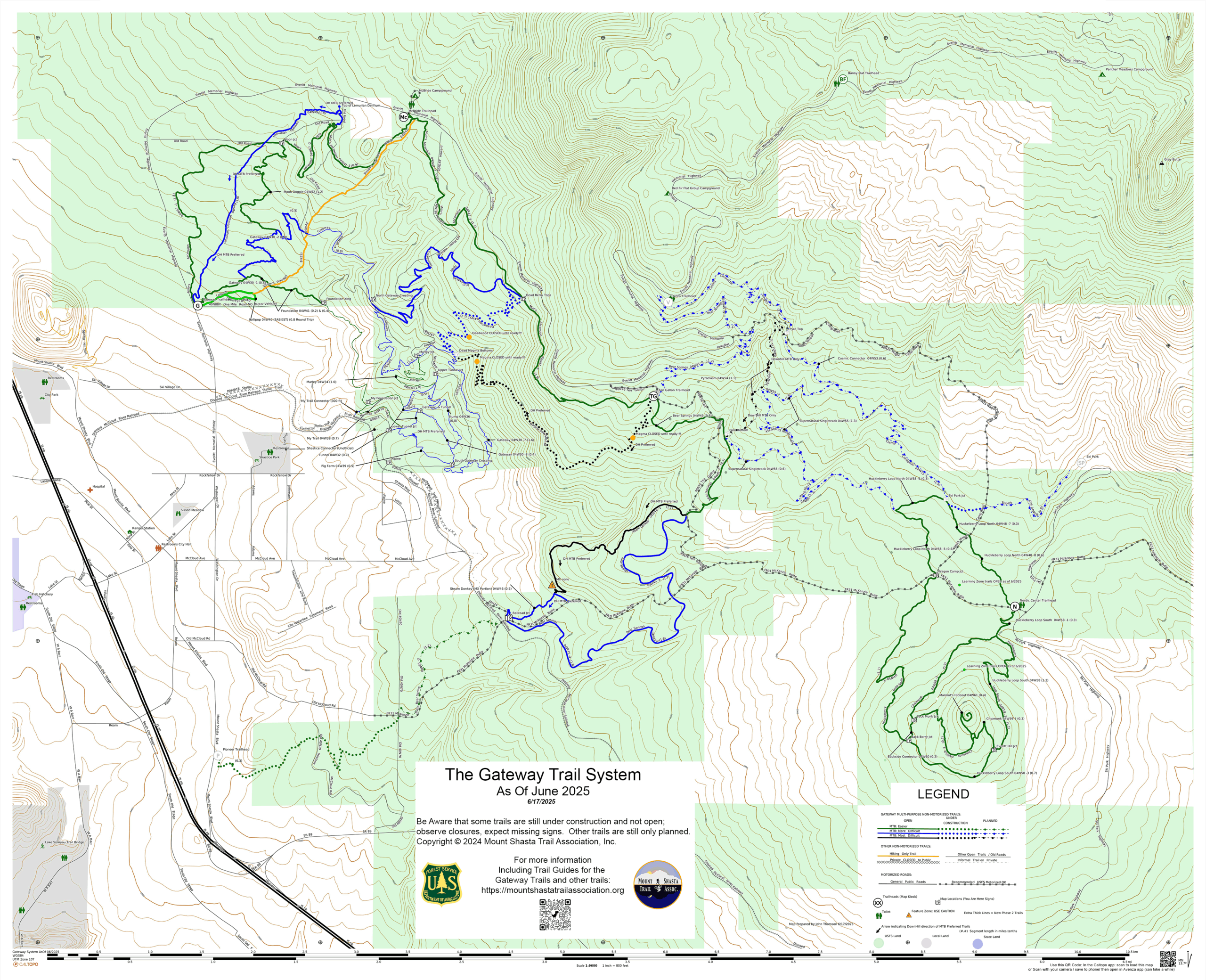
Current Trail Map (Check back for updates as new trails are added)
Updated 6/17/2025 with trails built in 2023 and 2024 plus those under construction and planned. Please do not use trails under construction and comply with “Trail Closed” signs: doing so is unsafe and will damage trails not yet compacted. A listing of trails shown on this map as under construction or planned that are opened before this map is replaced will be posted at the trailheads. Click the map below on your phone or a PC to open in a new tab: you can then zoom and scroll it using your phone or browser default zoom/pan controls.

Other Maps
The new trails have been added to OpenStreetMap.org and should be showing up in the default background maps for the biking / hiking apps shortly.
A printable 2 page PDF map is available by clicking on either of the two images below (Color or Black & White) . They are tabloid (11×17) size, but can be discerned when printed to fit letter size paper. These have been updated to June 2025 status.


Note that the links below may not be updated in a timely manner:
Trail Details
As of June 2025 there are four open trailheads (Two more are planned to open in 2025) (Search Google Maps for them)
The Gateway trail begins by the kiosk in the parking area – note that the trail curves north from the parking lot, and is not the gated forest road. It climbs and winds around gently for several miles before it crosses the gravel Forest Service Road 40N88X. From here you can continue on the trail or take the road back to the trailhead. Continuing, you come to the same road again at Marley Junction and have the choice of taking the Marley Trail down to the Tunnel Trail and Stellar Lane, or continuing on the Gateway.
Continuing on Gateway it climbs gently up the side hill, then contours over to Forest Service Road 40N16Y, and down to the Tunnel Trail and Steller Way (FS Road 40N24) at the Lower Tunnel Junction. If you go out via Stellar Way, note that you will be crossing private lands that lack public use easements. Otherwise, you can return to the trailhead from Lower Tunnel Junction via a variety of trail options. (Trail descriptions for the numerous other trails will be developed)
Controlling Agency:
Mount Shasta Ranger Station
Shasta-Trinity National Forest
204 West Alma, Mount Shasta, CA 96067
(530) 926-4511 www.fs.fed.us/r5/shastatrinity
Directions to Trailhead:
From the I-5 Central Mount Shasta exit, travel .7 mile east on Lake Street and then follow the curve as the road becomes Everett Memorial Highway. Trailhead is on the right just after you pass the last home and enter national forest lands.
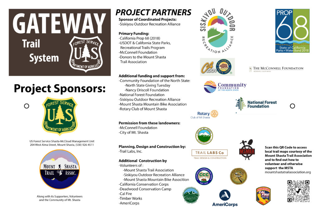
It has and will continue to take a big community effort to make the Gateway Trail System a success. Here are the organizations that are part of this effort as of 2025:
Support MSTA
MSTA develops and maintains trails in the Mount Shasta area, and advocates for hiking, biking and equestrian access. We are a volunteer-based 501(c)(3) non-profit organization and count on your support. Please consider giving back to your trails!