Forest Service News Release — Gateway Phase 2

Gateway Phase 2 Trail Project gains momentum

Contact(s): Josef Orosz, Public Affairs Specailist, 530 226-2322

MT. SHASTA, Calif. — The Shasta McCloud Management Unit of the Shasta-Trinity National Forest, in partnership with the Mt. Shasta Trail Association (MSTA), has finalized and signed the Gateway Phase 2 Environmental Assessment and Decision Notice which will allow for the following:

•              Construct 44.8 miles of new multi-use, non-motorized trails and 1.7 miles of trail that would be designed and permitted to equestrians and hikers only.

•              Construct two new day-use trailheads at Ten Gallon Plantation and the south side of the Everitt Memorial Highway across from the McBride Springs Campground.

•              Develop two existing recreation facilities as day-use trailheads at the John Everitt Vista Point and the Nordic Center on the Ski Park Highway.

•              Expand the McBride Springs Campground by adding a loop for 8-12 campsites.

•              Decommission unauthorized, unsustainable, user-created trails and trail segments in the project area.

The project area encompasses over 5,000 acres joining the existing 11.4 mile Gateway trail system off the Everitt Memorial Highway and Ski Park Highway, and contributes to the community’s “100 miles of Trail” campaign that launched in 2013 by MSTA and BikeShasta.

The proposed trail expansion has been designed to address multiple non-motorized trail users – hikers, trail runners, mountain bikers, and equestrian riders and incorporates consideration for trail-user objectives and desired experiences. This resulted in a “zoned” approach to the trail network that includes:

1.             Community Zone – close to town and easy to access, designed to build upon the existing Gateway network and creates more opportunities to quickly get out and enjoy the forest.

2.             Learning Zone (Discovery Center) – trailhead will be located at the Nordic Center, a short connection to the Mt. Shasta Ski Park, and mellow, rolling terrain with fantastic views all around. The Learning Zone will be ideal for those new to trails and will provide a series of loops that allow users to begin easy and add mileage if they feel up to the challenge.

3.             Big Mountain Zone – designed to provide a variety of trail experiences, but with an emphasis on mountain biking, including a portion where the “preferred-use” would be mountain biking. The Vista Point trailhead will function as a drop point in which users can descent into an assortment of routes ranging from intermediate level flow trails, to advanced downhill directionally designed trails, and connect with the Community or Learning Zones.

Over the last two years, the Forest Service has worked closely with the MSTA, who funded the NEPA analysis and completed the technical resource reports and Environmental Assessment following Forest Service guidelines. “This project was truly a community-led effort with support from all user groups, local businesses, and residents. It is an exciting time for our area with such an emphasis on recreation and tourism. This project compliments the designation of the city of Mt. Shasta as a Pacific Crest Trail Town and the larger concept of the Mount Shasta Trail Partners,” explained Shasta McCloud Management Unit District Ranger, Carolyn Napper. “This project provides the Forest Service an opportunity to work with the City of Mt. Shasta and surrounding areas to diversify the economic base of the community and promote partnerships with user groups to assist in the operation, maintenance, and developed of recreation sites and facilities.” 

With the grant funding the Mt. Shasta Trail Association received from the McConnell Foundation in 2017, trail building will begin in the spring of 2020 in the Big Mountain Zone. Construction will be a phased approach and once trail segments have been integrated into the National Forest System Trails system they will be open for public use. Both the Forest Service and the MSTA is continuing to apply for additional grant funding (Prop 68 and Recreation Trails Program) to support the construction and maintenance into the future.

“The completion of the environmental analysis and the signing of a decision for the Gateway Phase 2 Trail Project is a monumental event for the Trail Association and all of our donors and partners — especially the support we got from the local Forest Service employees,” stated Mt Shasta Trail Association board member, John Schuyler. “We see national forest lands as key to our goal of making southern Siskiyou County a destination for sustainable trail-based recreation, and this project demonstrates how we and the Forest Service can work together and accomplish common goals.”

For more information about this project visit https://www.fs.usda.gov/project/?project=53089. A larger image of the trail project is available at https://www.fs.usda.gov/Internet/FSE_DOCUMENTS/FSEPRD677468.pdf.

Hike to Rock Fence Lake — Saturday September 21, 2019

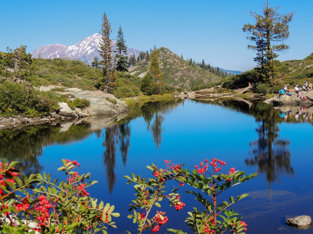
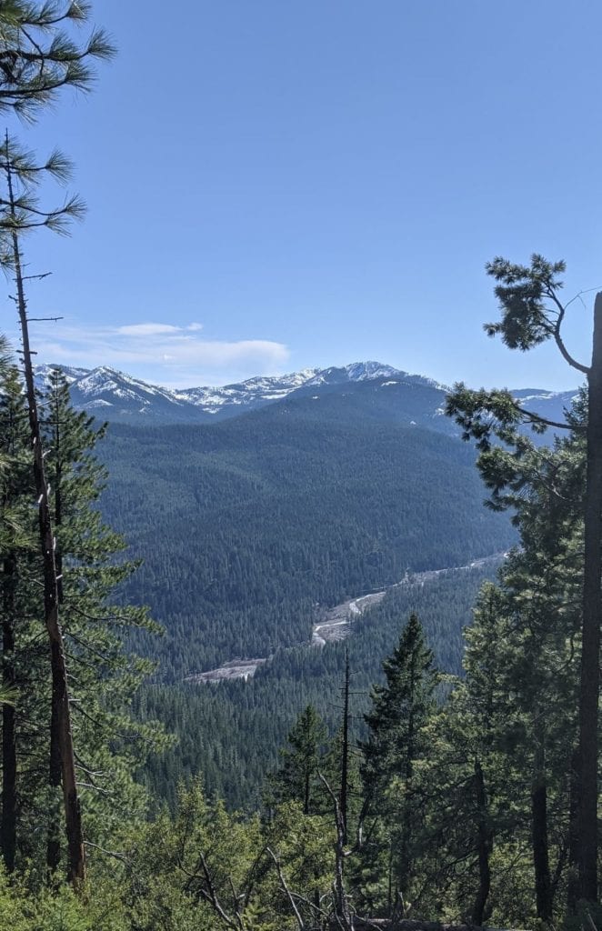
The Mount Shasta Trail Association invites the public to join them on a moderate hike to one of the jewels of our area recently added to our national forest lands: Rock Fence Lake. 

This lake is in the Scott Mountains, just east of Kangaroo Lake and is on one of the sections the Forest Service obtained earlier this year working with the Pacific Crest Trail Association and the Trust for Public Lands.  We will drive about 1-1/2 miles on a good unpaved forest road (small SUV’s ok) before parking and hiking the rest of the way (about 2 miles each way) on a much rougher, but very walk-able road.  Elevation gain is a little less than 1000 ft.   

Meeting time and place is 9 AM at 111 Morgan Way in front of the Best Western Tree House in Mount Shasta.  We will pass by the Gazelle Grange no earlier than 9:40 AM and pick up any who are waiting there at that time. Bring lunch, sun protection, and water.  For information contact John Thomson at 530 926-4430.

Our Destination

John Thomson Joins MSTA Board of Directors

John maintaining trails

The Mount Shasta Trail Association is pleased to announce that John Thomson has joined its Board of Directors.

John has spent a good portion of his entire life in Mt Shasta.  As a descendant of a true 49er, he has continued a family tradition of loving the California mountains (his great grandfather was photographing them before Ansel Adams).  He learned to ski in the Old Ski Bowl, has climbed THE MOUNTAIN 4 times, and picked up his Dad’s love of exploring and navigating.

Back in 1967 John helped build a family cabin on Hill Rd.  More recently, he and his wife Eugenie have remade the cabin into their home and have been true Mt. Shasta full-timers since 2017.

John followed his passion for public transit by getting both an BS and MS in Civil Engineering at Stanford. His career was entirely spent working as a consultant to public transportation agencies, generally in project management or related roles.

His favorite activities are hiking, bike riding, skiing, snow shoeing, photography, exploring and improving his home. Before an old neck injury stopped him, he was a champion sailor.

You can find John leading a hike (or other “wander”) somewhere in our area just about every week as Scribe for the Siskiyou Wanderers.

Lynda Hardy Joins MSTA Board of Directors

Trails Challenge completed!

The Mount Shasta Trail Association is happy to announce that Lynda Hardy has joined its Board of Directors.

Lynda is a long time community leader and has lived and worked in Siskiyou County for 42 years.  Now happily retired, Lynda worked for 32 of those years teaching Elementary School in Mount Shasta and Dunsmuir. She was selected and worked as an Educational Science Consultant for the prestigious Lawrence Hall of Science based out of Berkeley, CA.

Lynda was one of the founding members of the Mountain Runners non-profit organization.  During her years volunteering for Mountain Runners, she worked as the co-director of many Fourth of July Races and Winter Triathlons.  She co-coordinated and grew the Fun Runs successfully and was active in its fundraising campaigns.

An avid skate and backcountry skier, Lynda also continues to hike and mountain bike our local trails.  Some of her other interests are sailing and painting.

Trail Crew Repairs City Park Raised Walkway

After

Recently, Alan Neviolini from City Parks contacted MSTA Board Director Glenn Harvey with a support request.  One of the very old raised walkways near the headwaters spring had become dangerous, and Alan asked that our trail crew help repair it to be usable for the rest of the season.  So, we did!  One part that was funny is that there is so much use in the area that visitors wanted to use the walkway while Glenn’s crew were working on it!  The original walkway was built on logs placed directly in the water, and over time they have dissolved – literally.  Thanks to Mike Rodriguez for the opportunity to help make this part of the park safe to use again, and thanks to Rotary.

Before


Hike to the Deadfall Lakes and Mount Eddy — Saturday August 3, 2019

photo courtesy of wikipedia.org

For the most amazing views, join the Mt. Shasta Trail Association on a day hike to pristine Deadfall Lakes and to the top of Mt. Eddy slated for August 3rd.  This 10-mile round-trip hike starts out gently on the Pacific Crest Trail at the Parks Creek Trailhead to the multiple lakes and then becomes challenging as we gain 2,250 feet to the summit at 9,025 feet.

Mt. Eddy was formed between some 400 million years ago from peridotite, a volcanic form of serpentine.  This type of rock, ultramafic, is high in magnesium and low in calcium, and as such the soils derived from this material constitute a harsh growing medium for most plants.  Like with other serpentine areas, the result is that some plants adapt to the harsh conditions, taking advantage of the relative lack of competition, and evolve to become endemic to the site.  The iron contained in the rock rusts, giving it its reddish tint.  It is the highest mountain in the Trinity Divide — a sub-range of the Klamath Mountains — the highest point in Trinity County, and the highest mountain west of Interstate 5.  The mountain was named after Olive Paddock Eddy, the first woman to climb Mt. Shasta.  From this majestic peak we will be able to see Lassen Peak, Mt. McLoughlin, the Scott Mountains, the Eddy Range, Black Butte, Castle Crags Spire and of course Mt. Shasta towering over everything in sight.

Participants will meet 8 AM at 111 Morgan Way Mt Shasta, in front of the Best Western Tree House Motor Inn.  OR participants can meet the group at 8:30 at the I 5 Edgewood Rd exit on the west side of I-5.  Bring lunch, sun protection, a snack and water — and if interested — a bathing suit for a refreshing swim.  Hiking poles are recommended.  Expect to return by 6 PM.  For further questions call John Thomson at 530 926 4430.

Hike to Gray Rock Lakes — Saturday July 20, 2019

Timber Lake — One of the Gray Rock Lakes

On Saturday, July 20th, the Mount Shasta Trail Association invites the public on a moderate 2.5 mile hike with a 600 foot elevation gain to Gray Rock Lakes above the south fork of the Sacramento River. While the trail is a bit of a scramble at times, the spectacular views and the pristine lakes make it well worth the effort. Four-wheel drive vehicles with high clearance are needed to get to the trailhead. We will be carpooling as there is limited parking.

The meeting time and place is 8:00 am at 111 Morgan Way in Mt Shasta, in front of the Best Western Tree House Motor Inn. Bring water, lunch, sun protection and if interested, a bathing suit for a refreshing swim. A hiking pole is recommended. We will return by 4 pm. For further questions call John Thomson at 530-926-4430.

Mount Shasta Trail Challenge

This week’s 4th of July celebration is the kickoff of the Mount Shasta Trail Challenge — running through December 31st.  If you weren’t able to pick up a passport at the Street Fair booth, you can go to their website and download a PDF of the passport.  Here’s the link

10,000 acre Land Deal Along the Trinity Divide Benefits the Pacific Crest Trail

Bull Lake

Just last week it was announced that over 10,000 acres of private timber industry lands have been purchased for addition to the Shasta-Trinity and Klamath National Forests.  The land acquisition was spearheaded by our partners at the Pacific Crest Trail Association as these lands contain a 17-mile stretch of the National Scenic Trail that goes from Mexico to Canada.  These parcels are literally in our backyard as they are scattered from Castle Crags to Scott Mountain and contain a diversity of landscapes, geology and plants.

Here’s some links for more information on this great event:

PCTA

SF Chronicle